Summary
Contents
Subject index
Geomorphology is the study of the Earth's diverse physical land surface features and the dynamic processes that shape these features. Examining natural and anthropogenic processes, The SAGE Handbook of Geomorphology is a comprehensive exposition of the fundamentals of geomorphology that examines form, process, and history in the discipline. Organized into four sections, the Handbook is an overview of foundations and relevance, including the nature and scope of geomorphology, the origins and development of geomorphology, the role and character of theory in geomorphology, the significance of models and abstractions to geomorphology; techniques and approaches, including geomorphological mapping, field observations and experimental design, remote sensing in geomorphology, quantifying rates of erosion, measuring fluid flows and sediment fluxes, dating surfaces and sediment, GIS in geomorphology, and modelling landforms and processes; process and environment, including rock weathering, the evolution of regolith, hill slopes, riverine environments, glacial environments, periglacial environments, coastal environments, desert environments, karst landscapes, environmental change and anthropogenic activity; and environmental change, including geomorphology and environmental management, geomorphology and society, and planetary geomorphology.
Colour Plates
Plate 1 Map of New Orleans in 1895, showing urban development on the natural levees of Mississippi River main channel (e.g. French Quarter), and of former distributary channels, such as Metarie and Gentily ridges, both occupied by roads of the same name. (US Department of War, 1895)
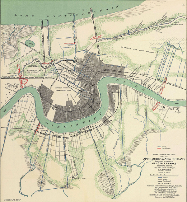
Plate 2 Sediment budget for Central Valley of California, 1850 to present. (Adapted from Kondolf, 2001)
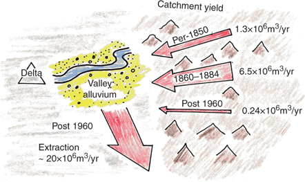
Plate 3 Three examples of regional landform maps of Australia, showing the same part of the eastern part of the continent. (a) extract from Lobeck (1951) showing the use of hachures. (b) extract from Löffler and Ruxton (1969), showing a polygon map derived from land system mapping. (c) extract from Pain et al. (in press) showing a polygon map compiled from the SRTM 30′ DEM (see Pain, 2008)
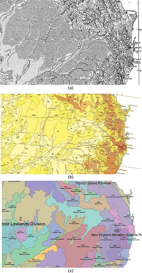
Plate 4 Landform map of the Po Delta, with partial legend. (From Bondesan et al., 1989; see also Castiglioni et al., 1999)
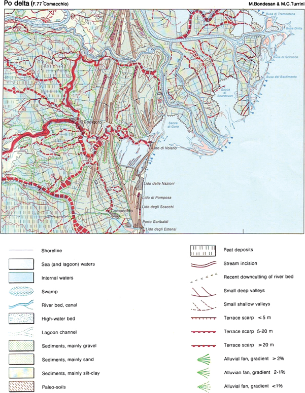
Plate 5 Principle of imaging spectroscopy. Each pixel in the 224 bands samples nearly continuously the VNIR spectrum of the terrain
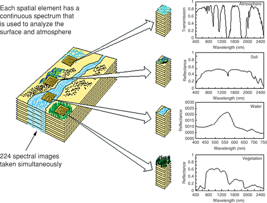
Plate 6 Radar penetration of dry sediments: Nile River. The top image is a hand-held photograph from the Space Shuttle in November 1995 and shows the Nile River in Sudan. The river is brownish due to silt. The lower image is from SIR-C and is a color composite of L-band (25 cm wavelength) and C-band images. Note the old channel of the Nile shows up in the lower radar image, but not the hand-held image, where sand is seen to cover the area
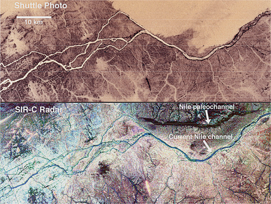
Plate 7 Lidar DEM showing a forested fault scarp in the state of Washington. (a) Bare-earth lidar DEM showing prominent north–south lineations due to glaciation and east–west fault scarps. (b) Google Earth image of same area showing extensive forest cover; lidar penetrates between trees and senses the land surface. (Public-domain lidar data from Puget Sound Lidar Consortium; http://pugetsoundlidar.ess.washington.edu/index.html)
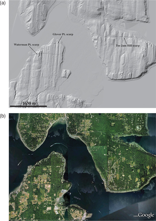
Plate 8 (a) A schematic showing their interpretation of calcrete formation. (From Wright and Tucker, 1991) (b) A nodular calcrete from Broken Hill, New South Wales, formed within the pedogenic zone of and alluvial/aeolian regolith. Here much of the carbonate is thought to be derived from dry lakes and lacustrine environments to the west of Broken Hill
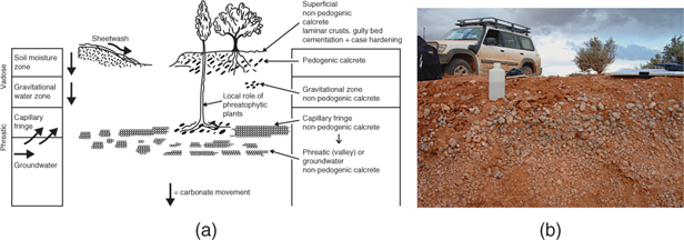
Plate 9 (a) Model of ice sheet/valley glacier frontal terrestrial margin. (b) Model of ice sheet/valley glacier floating subaquatic margin
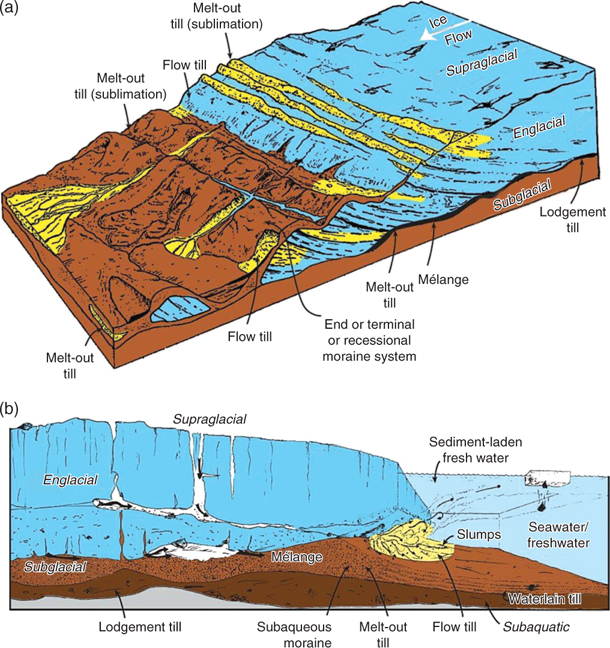
Plate 10 Glacial valley incision producing a U-shaped valley, the Korok River Valley, Torngat Mountains, Labrador, Canada. (Photograph courtesy John Gosse)
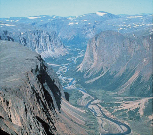
Plate 11 Erosional landscape system due to alpine glaciation. (Modified from Tarbuck and Lutgens, 2003)
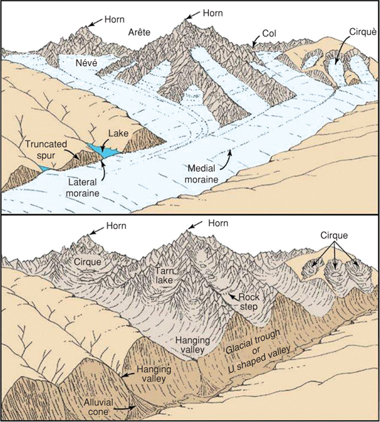
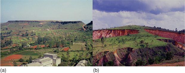
Plate 12 (a) Tabular hills in Panchagani, India. Weathered lavas at this site are capped by a thick ferricrete duricrust. (b) Deeply decomposed granite-gneiss below convex hill in eastern Brazil, now dissected by canyon gullies (height ~ 50–100 m)
- Loading...
Get a 30 day FREE TRIAL
-
 Watch videos from a variety of sources bringing classroom topics to life
 -
Read modern, diverse business cases
-
Explore hundreds of books and reference titles
Read next

More like this
Sage Recommends
We found other relevant content for you on other Sage platforms.
Have you created a personal profile? Login or create a profile so that you can save clips, playlists and searches