Entry
Reader's guide
Entries A-Z
Subject index
Washoe
The Washoe (also spelled Washo) tribe built their way of life around change, moving in cyclical patterns across their vast homeland. Instead of transforming land to suit survival needs, the Washoe learned, over thousands of years, to anticipate the seasons which led them to diverse and abundant food sources. A dialogue developed between the Washoe and their land. Elders passed the accumulated knowledge of food location and availability from generation to generation, through lessons and stories.
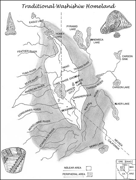
Prior to Euro-American settlement the Washishiw, or Washoe, occupied a land base that stretched from modern-day Susanville, California, in the north to Sonora Pass, California, in the south. The summits of the Sierra provided the western boundary of Washoe territory, while the eastern limits of the Pine Nut mountain range delineated an eastern border, so that their territory included a large portion of the Carson River Valley. Within their land base lay Daowaga, “the edge of the lake,” Lake Tahoe, which straddles the modern-day boundary between California and Nevada. Today Lake Tahoe serves a constant stream of tourists who come for the winter snow, summer sun, or casino nightlife. Before Euro-American colonization the pristine lake served as the nucleus of the Washoe way of life, and the spiritual center of their world.
The Seasonal Cycle of the Washoe
The Washoe made use of three contiguous geographical and biological zones. The higher elevations around Lake Tahoe, the boreal zone, contained rich forests of pine, fir, and hemlock trees. The forests contained abundant animal life including deer, antelope, and mountain sheep. Many lakes and streams could also be found in the boreal zone. These bodies of water contained several varieties of trout that represented a staple of the Washoe diet.
Near the eastern foot of the Sierra, community members made use of the transition zone, consisting of piñon pine, sagebrush, and juniper. Pine nuts, another staple of the Washoe diet, represented the largest food supply in this zone, though small game such as rabbits, groundhogs, and some deer could be found there. The last zone, east of the Sierra, anthropologists have labeled the piedmont. This zone contained many valleys, streams, and small lakes where fish, waterfowl, plants, and game thrived.
There were no linguistic or political divisions among the Washoe. Loosely organized branches inhabited far-flung and separate geographical locations during the winter but came closer together, living around Daowaga for the summer. The Washoe from the north, the Welmelti; those from the south Hungalelti, who resided in what is now Alpine County; and the Pauwalu, who lived in Carson Valley; made camps at separate locations on the lake shore.
Even within the branches the Washoe did not live in concentrated villages. Families generally lived together in groups of 2–10 homes, which they referred to as the “bunch,” or “many people living near one another.” The regular settlement areas on the eastern valley floors developed near water sources. These settlement areas remained intact throughout the year. While most community members traveled, some elders, infants, and caretakers maintained the permanent home sites.
Traditional Washishiw ...
- American Indians
- American Indian Migration to Phoenix, Arizona Apache
- Arapaho
- Assiniboine
- Blackfoot Nation
- Bureau of Indian Affairs
- Cahuilla Nation
- California Indians of the North Coast and Northwestern Coast
- California Indians of the Northern Mountains
- California Indians of the Northern Valley
- Chemehuevi
- Cheyennes
- Creek Nation
- Crow Nation
- Cupeños
- Gabrielino
- Gros Ventre
- Hopi
- Juaneños
- Kumeyaay (Diegueño, I'ipay, and Tipai)
- Lakotas
- Luiseño
- Maidu
- Mojave
- Nez Perce
- Northern Pueblo
- Palouse Indians
- Trail of Tears
- Upland Yumans
- Utes
- Washoe
- Yakama
- Yokuts
- Biography
- Austin, Stephen Fuller
- Bartleson, John
- Bass, Charlotta A. Spear(s)
- Bidwell, John
- Bloom, Jessie S.
- Brent, Joseph Lancaster
- Carr, Jeanne Carver Smith
- Chapman, Joseph
- Dellums, Cottrell Lawrence
- Duniway, Abigail Scott
- Feldenheimer, Edith
- Foltz, Clara Shortridge
- Foote, Mary Hallock
- Frank, Ray
- Fremont, John Charles
- Gale, William Alden
- Gianforte, Greg
- Hartnell, William
- Harvey, Frederick Henry
- Irvine, James Harvey
- Jacks, David Baird
- Percival, Olive May
- Pittman, Tarea Hall
- Reed, John Thomas
- Singleton, Benjamin
- Strauss, Levi
- Sutter, Johann August
- Thrall, William H.
- Van Nuys, Isaac Newton
- Wilson, Benjamin Davis
- Winnemucca, Sarah
- Cities and Towns
- Billings, Montana
- Bisbee and Douglas, Arizona
- Boise, Idaho
- Boyle Heights, California
- Bozeman, Montana
- Brigham City, Utah
- Butte, Montana
- China Lake, Inyokern, and Ridgecrest, California
- Cody, Wyoming
- Dearfield, Colorado
- Denver, Pueblo, Boulder, Fort Collins, and Colorado Springs, Colorado
- Fort Worth, Texas
- Fresno, California
- Gilead, Kansas
- Goldfield, Nevada
- Grass Valley, California
- Great Falls, Montana
- Helena, Montana
- Huntington Beach, California
- Jackson, Wyoming
- Julian, California
- Kalispell, Montana
- Lake Havasu City, Arizona
- Las Vegas, Nevada
- Last Chance Gulch, Montana
- Leadville, Colorado
- Lewiston and Coeur d'Alene, Idaho
- Libby, Montana
- Lincoln, Nebraska
- Los Angeles, California
- Miles City, Montana
- Mining Ghost Towns
- Missoula, Montana
- Moab, Utah
- Moscow, Idaho
- Nampa, Idaho
- Nicodemus, Kansas
- Northwood, North Dakota
- Omaha, Nebraska
- Park City, Utah
- Phoenix, Arizona
- Prescott, Arizona
- Price, Utah
- Rawhide, Nevada
- Rexburg, Idaho, and the Minidoka Project
- Rhyolite, Nevada
- Salt Lake City, Utah
- San Antonio, Texas
- San Diego, California
- San Dimas, California
- San Francisco, California
- Santa Ana River Valley
- Santa Ana, California
- Santa Fe, New Mexico
- St. George, Utah
- Sun City, Arizona
- Tacoma, Washington
- Temecula, California
- Tombstone, Arizona
- Tonopah, Nevada
- Topeka, Kansas
- Tucson, Arizona
- Virginia City, Montana
- Visalia, California
- Wichita, Kansas
- Economic Change and War
- Defense Industry
- Dry Farming
- Farming Families on the Oregon Frontier
- Iran-Iraq War and the Migration of Iranian Youth to California
- Military Base Closures
- United States Marine Corps Recruit Depot San Diego
- World War I Americanization Programs in California
- World War II Defense Industries
- World War II–Postwar Effects on Western Migration
- Ethnic and Racial Groups
- African American Communities in California
- Anglo Migration to Southern California Before the Depression
- Basque Americans
- Chileans and the California Gold Rush
- Chinese Immigration
- Czechs and Swedes in Saunders County, Nebraska
- Euro-American Migration on the Overland Trails
- French Basques of Bakersfield, California
- Frisians
- Irish in the West
- Koreatown
- Little Italy
- Little Tokyo and Japantown
- Mexican Migration to California
- Okies
- Pacific Islanders
- Slaves in California
- Vietnamese American Women
- Immigration Laws and Policies
- Asian Immigration Law
- Chinese Exclusion Act
- Forced Migration of Anarchists
- Forced Migration of Italians During World War II
- Gentleman's Agreement
- German and Italian Internment
- Immigration Act of 1965
- Immigration and Naturalization Service (INS)
- Immigration Reform and Control Act of 1986
- Indian Removal Act of 1830
- Japanese Internment
- Lawyers and Legislation
- Operation Wetback
- Proposition 187
- War Brides of Montana
- World War II Relocation Program
- Libraries
- Natural Resources Events and Laws
- Alien Land Law of 1913
- Arizona Copper Discoveries
- Black Hills Gold Rush of 1874
- Comstock Lode, 1859
- Enlarged Homestead Act of 1909
- Fraser River Gold Rush of 1858
- Frisco Mine, Beaver County, Utah
- Helena's Exploited Resources
- Homestead Act
- Idaho Silver Strikes
- Logging
- Mineral Land Policy
- Nevada's Mining Discoveries of the 20th Century
- Nineteenth-Century Land Policy
- Pick-Sloan Plan of 1944
- Pike's Peak Rush
- Rexburg, Idaho, and the Minidoka Project
- The Way West
- Loading...
Get a 30 day FREE TRIAL
-
 Watch videos from a variety of sources bringing classroom topics to life
 -
Read modern, diverse business cases
-
Explore hundreds of books and reference titles

Read next

More like this
Sage Recommends
We found other relevant content for you on other Sage platforms.
Have you created a personal profile? Login or create a profile so that you can save clips, playlists and searches