
Entry
Reader's guide
Entries A-Z
Subject index
Park City, Utah
Transforming mining and ranching towns into recreational tourist destinations is big business in the Rocky Mountains. In the past 40 years, towns poor in economic opportunities but rich in scenic beauty have capitalized on their environment. Park City, Utah, is such a town. Nestled in a long valley at the base of the Wasatch Mountains, Park City began life as a mining boomtown. After the profitability of the mines declined and most shut down, many residents moved elsewhere. Yet a group remained and began profiting off the surface wealth and aesthetics of the landscape surrounding the town. Within a decade Park City metamorphosed from a failed mining town into a successful year-round tourist destination. Recent studies of similar transformations in the West have focused on the cultural and economic conditions that facilitated the transition. This focus ignores the connection between these towns and their environments. Understanding the intrinsic and very profitable link between Park City and its natural landscape sheds light on this important aspect of Western history. This entry seeks to identify this
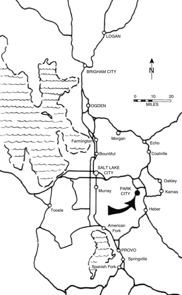
Figure 1 Park City, Utah
relationship and understand how one community benefited from the environment. Yet despite how profitable Park City's environmental relationship became, there were unforeseen consequences of its relationship with the land.
The Land
Park City is located at the intersection of the Uintah and Wasatch mountain ranges. As the mountains form a T intersection, Park City sits on the northern slopes of the Uintah Mountains, east of the Wasatch Front. Above the town, a 10,000-foot ridge forms the dividing line between Salt Lake and Summit Counties, and then gradually descends to the valley floor. The ridge also protects several natural bowls, or cirques, from the high winds associated with storm systems flowing from the west. This natural feature proved to be very advantageous once the town moved to a ski resort economy.
The flora covering the slopes of the Uintahs around Park City is divided into vegetation zones, expressions of changes in altitude. The lowest elevations, specifically the valley floor, are covered by a combination of grasses and sagebrush. Rising above the valley floor, the foothills display a mixture of Gambel oak, sometimes referred to as scrub oak, and mountain maple, which thrives on the northern, less exposed slopes. In the higher elevations, aspen, white fir, Douglas fir, and spruce trees blend together on the slopes before they give way to moraine at the tree line.
Because it is much higher in elevation than Salt Lake City, Park City enjoys a cooler and wetter climate. Summer temperatures average 10 to 15 degrees cooler while winter temperatures can average as much as 25 degrees cooler. The Sierra Nevada Mountains in eastern California cast a rain shadow over Utah's Great Basin, but the Wasatch Mountains run perpendicular to the prevailing winds, producing an orographic barrier that induces precipitation. A narrow zone at the base of the Wasatch Mountains receives 13 to 18 inches of precipitation annually, while the higher elevations typically receive more than 50 inches. The higher elevations receive the majority of their precipitation in snow; the peaks surrounding Park City typically accumulate anywhere from 50 to 100 inches of snow each winter. The annual snowmelts send 8 to 10 million acre-feet of water surging down the drainages in late spring and early summer. This does not create a problem, because the Wasatch and Uintah's thickly vegetated watersheds handle the runoff.
...
- American Indians
- American Indian Migration to Phoenix, Arizona Apache
- Arapaho
- Assiniboine
- Blackfoot Nation
- Bureau of Indian Affairs
- Cahuilla Nation
- California Indians of the North Coast and Northwestern Coast
- California Indians of the Northern Mountains
- California Indians of the Northern Valley
- Chemehuevi
- Cheyennes
- Creek Nation
- Crow Nation
- Cupeños
- Gabrielino
- Gros Ventre
- Hopi
- Juaneños
- Kumeyaay (Diegueño, I'ipay, and Tipai)
- Lakotas
- Luiseño
- Maidu
- Mojave
- Nez Perce
- Northern Pueblo
- Palouse Indians
- Trail of Tears
- Upland Yumans
- Utes
- Washoe
- Yakama
- Yokuts
- Biography
- Austin, Stephen Fuller
- Bartleson, John
- Bass, Charlotta A. Spear(s)
- Bidwell, John
- Bloom, Jessie S.
- Brent, Joseph Lancaster
- Carr, Jeanne Carver Smith
- Chapman, Joseph
- Dellums, Cottrell Lawrence
- Duniway, Abigail Scott
- Feldenheimer, Edith
- Foltz, Clara Shortridge
- Foote, Mary Hallock
- Frank, Ray
- Fremont, John Charles
- Gale, William Alden
- Gianforte, Greg
- Hartnell, William
- Harvey, Frederick Henry
- Irvine, James Harvey
- Jacks, David Baird
- Percival, Olive May
- Pittman, Tarea Hall
- Reed, John Thomas
- Singleton, Benjamin
- Strauss, Levi
- Sutter, Johann August
- Thrall, William H.
- Van Nuys, Isaac Newton
- Wilson, Benjamin Davis
- Winnemucca, Sarah
- Cities and Towns
- Billings, Montana
- Bisbee and Douglas, Arizona
- Boise, Idaho
- Boyle Heights, California
- Bozeman, Montana
- Brigham City, Utah
- Butte, Montana
- China Lake, Inyokern, and Ridgecrest, California
- Cody, Wyoming
- Dearfield, Colorado
- Denver, Pueblo, Boulder, Fort Collins, and Colorado Springs, Colorado
- Fort Worth, Texas
- Fresno, California
- Gilead, Kansas
- Goldfield, Nevada
- Grass Valley, California
- Great Falls, Montana
- Helena, Montana
- Huntington Beach, California
- Jackson, Wyoming
- Julian, California
- Kalispell, Montana
- Lake Havasu City, Arizona
- Las Vegas, Nevada
- Last Chance Gulch, Montana
- Leadville, Colorado
- Lewiston and Coeur d'Alene, Idaho
- Libby, Montana
- Lincoln, Nebraska
- Los Angeles, California
- Miles City, Montana
- Mining Ghost Towns
- Missoula, Montana
- Moab, Utah
- Moscow, Idaho
- Nampa, Idaho
- Nicodemus, Kansas
- Northwood, North Dakota
- Omaha, Nebraska
- Park City, Utah
- Phoenix, Arizona
- Prescott, Arizona
- Price, Utah
- Rawhide, Nevada
- Rexburg, Idaho, and the Minidoka Project
- Rhyolite, Nevada
- Salt Lake City, Utah
- San Antonio, Texas
- San Diego, California
- San Dimas, California
- San Francisco, California
- Santa Ana River Valley
- Santa Ana, California
- Santa Fe, New Mexico
- St. George, Utah
- Sun City, Arizona
- Tacoma, Washington
- Temecula, California
- Tombstone, Arizona
- Tonopah, Nevada
- Topeka, Kansas
- Tucson, Arizona
- Virginia City, Montana
- Visalia, California
- Wichita, Kansas
- Economic Change and War
- Defense Industry
- Dry Farming
- Farming Families on the Oregon Frontier
- Iran-Iraq War and the Migration of Iranian Youth to California
- Military Base Closures
- United States Marine Corps Recruit Depot San Diego
- World War I Americanization Programs in California
- World War II Defense Industries
- World War II–Postwar Effects on Western Migration
- Ethnic and Racial Groups
- African American Communities in California
- Anglo Migration to Southern California Before the Depression
- Basque Americans
- Chileans and the California Gold Rush
- Chinese Immigration
- Czechs and Swedes in Saunders County, Nebraska
- Euro-American Migration on the Overland Trails
- French Basques of Bakersfield, California
- Frisians
- Irish in the West
- Koreatown
- Little Italy
- Little Tokyo and Japantown
- Mexican Migration to California
- Okies
- Pacific Islanders
- Slaves in California
- Vietnamese American Women
- Immigration Laws and Policies
- Asian Immigration Law
- Chinese Exclusion Act
- Forced Migration of Anarchists
- Forced Migration of Italians During World War II
- Gentleman's Agreement
- German and Italian Internment
- Immigration Act of 1965
- Immigration and Naturalization Service (INS)
- Immigration Reform and Control Act of 1986
- Indian Removal Act of 1830
- Japanese Internment
- Lawyers and Legislation
- Operation Wetback
- Proposition 187
- War Brides of Montana
- World War II Relocation Program
- Libraries
- Natural Resources Events and Laws
- Alien Land Law of 1913
- Arizona Copper Discoveries
- Black Hills Gold Rush of 1874
- Comstock Lode, 1859
- Enlarged Homestead Act of 1909
- Fraser River Gold Rush of 1858
- Frisco Mine, Beaver County, Utah
- Helena's Exploited Resources
- Homestead Act
- Idaho Silver Strikes
- Logging
- Mineral Land Policy
- Nevada's Mining Discoveries of the 20th Century
- Nineteenth-Century Land Policy
- Pick-Sloan Plan of 1944
- Pike's Peak Rush
- Rexburg, Idaho, and the Minidoka Project
- The Way West
- Loading...
Get a 30 day FREE TRIAL
-
 Watch videos from a variety of sources bringing classroom topics to life
 -
Read modern, diverse business cases
-
Explore hundreds of books and reference titles

Read next

More like this
Sage Recommends
We found other relevant content for you on other Sage platforms.
Have you created a personal profile? Login or create a profile so that you can save clips, playlists and searches