Entry
Reader's guide
Entries A-Z
Subject index
Green Belt
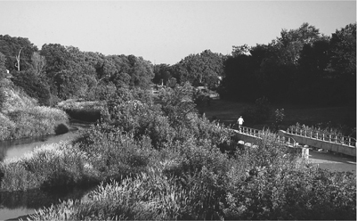
Greenery functions here as a conservation buffer in this green belt in suburban Des Moines, Iowa. Green belts are a popular tool for planners and citizens to foster a higher quality of sustainable city life
Many cities use green belts, or legally protected open space around a city, to create recreational opportunities for residents, preserve agricultural viability, and attempt to contain urban sprawl. Some green belts are held as undeveloped land, such as wetlands, hillsides, or forested lands, whereas others are protected as rural agricultural land. Green belts, although not an unproblematic solution, are an increasingly popular tool for planners, public officials, and citizens working toward fostering a higher quality of life in a more sustainable city. Maintaining open space around the city has long been an attractive solution for urban decision makers trying to combat the perceived ills of an increasingly urban society. For instance, as early as 1580, Queen Elizabeth I effectively created a green belt around London that prohibited any new building within three miles of the city wall. Turn-of-the-century British planner Ebenezer Howard, however, is considered the father of the modern green belt movement. With his Garden Cities concept, Howard theorized that a network of densely settled 1,000-acre cities surrounded by 5,000 acres of rural green belt could help to reform urban society. The rural agricultural belt would serve to keep each city distinct from neighboring settlements while also providing visual and spatial relief from potential urban congestion. Although Howard and his associates built only two garden cities in early-20th-century England, the planning ideas, particularly the green belt concept, had an important influence on new town planning elsewhere. In the United States’ New Deal era, for example, the Resettlement Administration created three small “green belt towns”—including the aptly-named Greenbelt, Maryland—that were modeled after Howard's concepts and featured prominent green belts.
Green belts emerged as a fashionable urban planning tool in the second half of the 20th century. By this time, evidence was mounting that, if unchecked, cities would expand rapidly into the surrounding countryside. This urban expansion into far-flung greenfields drove a quickly receding recreational, agricultural, and species-habitat frontier and contributed to a culture of increased automobile dependence, along with an economy based on even greater residential and infrastructure advancement. By the 1970s, forward-looking cities began to turn to green belts to combat the environmental, social, and economic challenges of urban sprawl. Green belts were designed to protect agricultural land, maintain species habitat, protect urban watersheds, provide scenic views and recreational spaces, and promote compact urban development.
Unless legally protected, however, the green belt of undeveloped land that naturally surrounds a city is likely to be constantly under threat as a result of urban expansion. Adopting an urban growth boundary is among the most common strategies for creating a secure green belt. An urban growth boundary is an officially adopted and mapped line that marks the spatial extent of urban or suburban development. The urban growth boundary typically is set in place for a considerable amount of time to discourage speculation at the rural–urban interface. Open space such as rural agricultural land, watersheds, parks, and golf courses are often allowed within the green belts formed outside the urban growth boundary. Green belts that have been protected through urban growth boundaries exist in London, Copenhagen, Vancouver, and other cities throughout the world. In the United States, the Pacific Northwest states of Oregon and Washington require cities to adopt urban growth boundaries. Other cities such as Boulder, Colorado, and several cities in the San Francisco Bay Area have voluntarily adopted urban growth boundaries to protect their green belts.
...
- City Organizations, Movements, and Planning
- Agenda 21
- Brownfields
- Carrying Capacity
- Charrette
- City Politics
- Civic Space
- Ecoindustrial Parks
- Environmental Impact Assessment
- Environmental Planning
- Green Communities and Neighborhood Planning
- Green Design, Construction and Operations
- Greenfield Sites
- Infrastructure
- Intermodal Transportation
- Millennium Development Goals
- Mitigation
- NIMBY
- Personal Rapid Transit
- Resilience
- Sustainability Indicators
- Sustainable Development
- Transit-Oriented Development
- Transportation Demand Management
- City Profiles
- Austin, Texas
- Bahía de Caráquez, Ecuador
- Bangkok, Thailand
- Barcelona, Spain
- Beijing, China
- Bogotá, Colombia
- Chattanooga, Tennessee
- Chernobyl, Ukraine
- Chicago, Illinois
- Copenhagen, Denmark
- Curitiba, Brazil
- Dongtan, China
- Dzerzhinsk, Russia
- Hamburg, Germany
- Kabwe, Zambia
- Kampala, Uganda
- La Oroya, Peru
- Linfen, China
- London, England
- Los Angeles, California
- Malmö, Sweden
- Mexico City, Mexico
- New York City, New York
- Norilsk, Russia
- Portland, Oregon
- Reykjavik, Iceland
- Rio de Janeiro, Brazil
- San Francisco, California
- Seattle, Washington
- Stockholm, Sweden
- Sukinda, India
- Sumgayit, Azerbaijan
- Sydney, Australia
- Tianying, China
- Vancouver, Canada
- Vapi, India
- Green City Challenges
- Adaptation, Climate Change
- Adaptive Reuse
- Air Quality
- Biodiversity
- Carbon Footprints
- Coastal Zone Management
- Combined Sewer Overflow
- Commuting
- Construction and Demolition Waste
- Denitrification
- Density
- Ecological Footprint
- Ecosystem Restoration
- Embodied Energy
- Energy Efficiency
- Environmental Justice
- Environmental Risk
- Food Deserts
- Food Security
- Garbage
- Greywater
- Gridlock
- Heat Island Effect
- Indoor Air Quality
- Landfills
- Light Pollution
- Natural Capital
- Nonpoint Source Pollution
- Ports
- Power Grids
- Recycling in Cities
- Sea Level Rise
- Stormwater Management
- Transit
- Waste Disposal
- Water Conservation
- Water Pollution
- Water Treatment
- Water, Sources and Delivery
- Watershed Protection
- Wetlands
- Green City Solutions
- Bicycling
- Biophilia
- Bioregion
- Bluebelts
- Bus Rapid Transit
- Carbon Neutral
- Carbon Trading
- Carpooling
- Cities for Climate Protection
- Citizen Participation
- Combined Heat and Power (Cogeneration)
- Community Gardens
- Compact Development (New Urbanism)
- Composting
- Congestion Pricing
- Conservation Subdivision
- Daylighting
- Distributed Generation
- District Energy
- Ecovillages
- Green Belt
- Green Energy
- Green Fleets (Vehicles)
- Green Housing
- Green Infrastructure
- Green Jobs
- Green Landscaping
- Green Procurement and Purchasing
- Green Roofs
- Greening Suburbia
- Greyfield Development
- Habitat Conservation and Restoration
- Healthy Cities
- Historic Preservation
- Infill Development
- LEED (Leadership in Energy and Environmental Design)
- Location-Efficient Mortgage
- Masdar Ecocity
- Mayors Climate Protection Agreement
- Parks, Greenways, and Open Space
- Renewable Energy
- Smart Growth
- Traffic Calming
- Universal Design
- Urban Agriculture
- Urban Forests
- Walkability (Pedestrian-Friendly Streets)
- Xeriscaping
- Loading...
Get a 30 day FREE TRIAL
-
 Watch videos from a variety of sources bringing classroom topics to life
 -
Read modern, diverse business cases
-
Explore hundreds of books and reference titles

Read next

More like this
Sage Recommends
We found other relevant content for you on other Sage platforms.
Have you created a personal profile? Login or create a profile so that you can save clips, playlists and searches