Entry
Reader's guide
Entries A-Z
Subject index
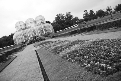
Curitiba, Brazil
Often referred to as the ecological capital of Brazil, Curitiba has legislation that provides tax incentives for green spaces in building projects. This has allowed the expansion of parks and green areas, like the Public Botanical Garden
The city of Curitiba is the capital of Paraná, a mainly agricultural state in the south of Brazil. The city is located 900 meters above sea level and 87 kilometers west of the Atlantic Ocean, near the coastal mountain ridge. Its land area covers approximately 435 square kilometers, and its population is around 1.8 million. It is known internationally for its progressive transportation system, social and environmental programs, preservation of the city's cultural heritage, and expansion of parks and green areas, and the city also has achieved international recognition for having charted an effective route to becoming a sustainable city.
Despite its achievements, Curitiba faces the same problems that metropolises around the world do, including social inequality, overcrowding, pollution, and limited public funding. What is different about Curitiba is that its planners have deployed creative and inexpensive ways to respond to these problems. This includes the investment in an extensive transportation system using buses, recycling programs that clean up the environment and also address poverty, and attracting new industry while expanding green spaces and using preserved historical areas to revitalize neighborhoods and to grow tourism.
The city's straightforward approach to city planning, unique not only within Brazil but also within the developing world, began many decades ago. The French planner and architect Alfred Agache developed the first plan to direct urban growth in Curitiba in 1943. At that time, the region's blooming agriculture industry attracted new settlers and immigrants, mostly from Europe. The government did not implement the plan at the time, but its main legacy was to introduce the concept of urban planning to Curitiba's citizens and government.
Urban Planning
In 1964, the municipal government put forward a call for proposals to prepare Curitiba for rapid and ongoing growth. A team of young, idealistic architects and planners from the Federal University of Paraná answered that call. In 1965, the government created the Curitiba Research and Urban Planning Institute, which is responsible for developing the city's master plan, studies, and projects, and for coordinating the urban planning activities. Their proposal addressed measures to minimize urban sprawl, reduce downtown traffic, preserve Curitiba's historic district, and provide easily accessible and affordable public transport. This proposal was adopted and came to be known as the Curitiba Master Plan.
During the 1970s, the development of the city was influenced by three main elements: the design and implementation of an integrated transport system, the development of the road network system, and land use legislation to allow environmental preservation, cultural services, and quality of life. These elements were later complemented by the development of the industrial district.
Curitiba's Transportation System
The creation of the road network in coordination with the master plan and land use legislation began construction and implementation in 1974. It encompassed the design of an urban plan that emphasized the linear growth along five structural axes. Each axis was designed as a triple road system. The central road has two exclusive express bus lanes. Parallel to the express bus lanes are two local roads running in opposite directions—one for traffic flowing into the city and the other for traffic flowing out of the city. The land use legislation encouraged large, high-density buildings along these corridors, mainly for services and commerce. Moving out of these central corridors are the residential neighborhoods.
...
- City Organizations, Movements, and Planning
- Agenda 21
- Brownfields
- Carrying Capacity
- Charrette
- City Politics
- Civic Space
- Ecoindustrial Parks
- Environmental Impact Assessment
- Environmental Planning
- Green Communities and Neighborhood Planning
- Green Design, Construction and Operations
- Greenfield Sites
- Infrastructure
- Intermodal Transportation
- Millennium Development Goals
- Mitigation
- NIMBY
- Personal Rapid Transit
- Resilience
- Sustainability Indicators
- Sustainable Development
- Transit-Oriented Development
- Transportation Demand Management
- City Profiles
- Austin, Texas
- Bahía de Caráquez, Ecuador
- Bangkok, Thailand
- Barcelona, Spain
- Beijing, China
- Bogotá, Colombia
- Chattanooga, Tennessee
- Chernobyl, Ukraine
- Chicago, Illinois
- Copenhagen, Denmark
- Curitiba, Brazil
- Dongtan, China
- Dzerzhinsk, Russia
- Hamburg, Germany
- Kabwe, Zambia
- Kampala, Uganda
- La Oroya, Peru
- Linfen, China
- London, England
- Los Angeles, California
- Malmö, Sweden
- Mexico City, Mexico
- New York City, New York
- Norilsk, Russia
- Portland, Oregon
- Reykjavik, Iceland
- Rio de Janeiro, Brazil
- San Francisco, California
- Seattle, Washington
- Stockholm, Sweden
- Sukinda, India
- Sumgayit, Azerbaijan
- Sydney, Australia
- Tianying, China
- Vancouver, Canada
- Vapi, India
- Green City Challenges
- Adaptation, Climate Change
- Adaptive Reuse
- Air Quality
- Biodiversity
- Carbon Footprints
- Coastal Zone Management
- Combined Sewer Overflow
- Commuting
- Construction and Demolition Waste
- Denitrification
- Density
- Ecological Footprint
- Ecosystem Restoration
- Embodied Energy
- Energy Efficiency
- Environmental Justice
- Environmental Risk
- Food Deserts
- Food Security
- Garbage
- Greywater
- Gridlock
- Heat Island Effect
- Indoor Air Quality
- Landfills
- Light Pollution
- Natural Capital
- Nonpoint Source Pollution
- Ports
- Power Grids
- Recycling in Cities
- Sea Level Rise
- Stormwater Management
- Transit
- Waste Disposal
- Water Conservation
- Water Pollution
- Water Treatment
- Water, Sources and Delivery
- Watershed Protection
- Wetlands
- Green City Solutions
- Bicycling
- Biophilia
- Bioregion
- Bluebelts
- Bus Rapid Transit
- Carbon Neutral
- Carbon Trading
- Carpooling
- Cities for Climate Protection
- Citizen Participation
- Combined Heat and Power (Cogeneration)
- Community Gardens
- Compact Development (New Urbanism)
- Composting
- Congestion Pricing
- Conservation Subdivision
- Daylighting
- Distributed Generation
- District Energy
- Ecovillages
- Green Belt
- Green Energy
- Green Fleets (Vehicles)
- Green Housing
- Green Infrastructure
- Green Jobs
- Green Landscaping
- Green Procurement and Purchasing
- Green Roofs
- Greening Suburbia
- Greyfield Development
- Habitat Conservation and Restoration
- Healthy Cities
- Historic Preservation
- Infill Development
- LEED (Leadership in Energy and Environmental Design)
- Location-Efficient Mortgage
- Masdar Ecocity
- Mayors Climate Protection Agreement
- Parks, Greenways, and Open Space
- Renewable Energy
- Smart Growth
- Traffic Calming
- Universal Design
- Urban Agriculture
- Urban Forests
- Walkability (Pedestrian-Friendly Streets)
- Xeriscaping
- Loading...
Get a 30 day FREE TRIAL
-
 Watch videos from a variety of sources bringing classroom topics to life
 -
Read modern, diverse business cases
-
Explore hundreds of books and reference titles

Read next

More like this
Sage Recommends
We found other relevant content for you on other Sage platforms.
Have you created a personal profile? Login or create a profile so that you can save clips, playlists and searches