Entry
Reader's guide
Entries A-Z
Subject index
Sea Level, Rising
SEA LEVEL RISE is caused by thermal expansion of the oceans, melting of glaciers and ice caps, melting of the Greenland and Antarctic ice sheets, and changes in terrestrial storage. Changes in sea level will be felt through increases in the intensity and frequency of storm surges and coastal flooding; increased salinity of rivers, bays, and coastal aquifers resulting from saline intrusion; increased coastal erosion; loss of important mangroves and other wetlands (the exact response will depend on the balance between sedimentation and sea level change) and its effect on marine ecosystems (i.e., coral reefs).
Global sea level rose by about 394 ft. (120 m.) during the several millennia that followed the end of the last Ice Age (approximately 21,000 years ago) before stabilizing between 3,000 and 2,000 years ago. Sea level indicators suggest that global sea level did not change significantly from then until the late 19th century, when the instrumental record of modern sea level change shows evidence for onset of sea level rise. Estimates for the 20th century show that global average sea level rose at a rate of about 1.7 mm. per year.
Satellite observations available since the early 1990s provide more accurate sea level data with nearly global coverage. This decade-long satellite altimetry data set shows that since 1993, sea level has been rising at a rate of around 3 mm. per year—significantly higher than the average during the previous half century. Coastal tide gauge measurements confirm this observation and indicate that similar rates have occurred in some earlier decades.
Sea level rise is currently determined by the employment of two techniques: the use of tide gauges and satellite altimetry. Tide gauges provide sea level variations with respect to the land on which they lie. To extract the signal of sea level change resulting from ocean water volume and other océanographie change, land motions need to be removed from the tide gauge measurement. Sea-level change based on satellite altimetry is measured with respect to the Earths center of mass and thus is not distorted by land motions, except for a small component resulting from large-scale deformation of ocean basins. The total 20th-century rise is estimated to be around 0.5 ft. (0.17 m.).
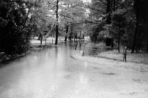
The Lower Patuxent River in Maryland, showing the flooding of low-lying areas by extreme high tides. If climate change causes sea level to continue to rise, this type of flooding will become increasingly common.
Sea-level rise is accelerating worldwide. Globally, 100 million people live within about 3 mi. (1 m.) of sea level. Eight to 10 million people live within 3 mi. (1 m.) of high tide in each of the unprotected river deltas of Bangladesh, Egypt, and Vietnam. Intergovernmental Panel on Climate Change (IPCC) reports estimate that the global average sea-level rose at an average rate of 1.8 (1.3–2.3) mm. per year between 1961 and 2003, and within that period, the rate of rise was faster between 1993 and 2003—about 3.1 (2.4–3.8) mm. per year. Overall, the IPCC concludes that there is high confidence that the rate of observed sea-level rise has risen from the 19th to the 20th century. The total 20th-century rise is estimated to be 0.17 (0.12–0.22) m. In 2001, IPCC projections were for a sea-level rise of between 9 and 88 cm. between 1990 and 2100 and a global average surface temperature rise of between 2.5–10.4 degrees F (1.4–5.8 degrees C). In 2007, IPCC projections based on different scenarios predict seal level rise from 0.18 to up to 0.59 mm. by 2099.
...
- Atmospheric Sciences
- Aerosols
- Anticyclones
- Atmospheric Absorption of Solar Radiation
- Atmospheric Boundary Layer
- Atmospheric Composition
- Atmospheric Emission of Infrared Radiation
- Atmospheric General Circulation Models
- Clouds, Cirrus
- Clouds, Cumulus
- Clouds, Stratus
- Condensation
- Convection
- Coriolis Force
- Cyclones
- Doldrums
- Evaporation and Transpiration
- Evolution of the Atmosphere
- Hadley Circulation
- Heat, Latent
- Heat, Sensible
- Hurricanes and Typhoons
- Hydrological Cycle
- Intertropical Convergence Zone
- Jet Streams
- Mesosphere
- Monsoons
- Precipitation
- Radiation, Absorption
- Radiation, Infrared
- Radiation, Long Wave
- Radiation, Microwave
- Radiation, Short Wave
- Radiation, Ultraviolet
- Rain
- Stratosphere
- Thermosphere
- Thunderstorms
- Trade Winds
- Troposphere
- Walker Circulation
- Waves, Gravity
- Waves, Internal
- Waves, Kelvin
- Waves, Planetary
- Waves, Rossby
- Weather
- Winds, Easterlies
- Winds, Westerlies
- Climate
- Abrupt Climate Changes
- Aerosols
- Albedo
- Anthropogenic Forcing
- Carbon Cycle
- Chaos Theory
- Climate Cycles
- Climate Forcing
- Climate Thresholds
- Climate Zones
- Climatic Data, Atmospheric Observations
- Climatic Data, Cave Records
- Climatic Data, Historical Records
- Climatic Data, Ice Observations
- Climatic Data, Instrumental Records
- Climatic Data, Lake Records
- Climatic Data, Nature of the Data
- Climatic Data, Oceanic Observations
- Climatic Data, Proxy Records
- Climatic Data, Sea Floor Records
- Climatic Data, Sediment Records
- Climatic Data, Tree Ring Records
- Detection of Climate Changes
- Earthshine
- El Niño and La Niña
- Gaia Hypothesis
- Global Warming
- Greenhouse Effect
- Greenhouse Gases
- History of Climatology
- History of Meteorology
- Hydrological Cycle
- Internal Climate Variability
- Methane Cycle
- Milankovitch Cycles
- Monsoons
- North Atlantic Oscillation
- Oxygen Cycle
- Seasonal Cycle
- Southern Oscillation
- Sunlight
- Thermodynamics
- Volcanism
- World Systems Theory
- Climate and Society
- An Inconvenient Truth
- Adaptation
- Alternative Energy, Ethanol
- Alternative Energy, Solar
- Alternative Energy, Wind
- Automobiles
- Bush (George W.) Administration
- Capitalism
- Clean Air Act, U.S.
- Clinton Administration
- Coal
- Conservation
- Culture
- Ecological Footprint
- Education
- Environmental Protection Agency (EPA)
- Framework Convention on Climate Change
- Geography
- Globalization
- Greenhouse Effect
- Greenhouse Gases
- Gross National Product
- Health
- Industrialization
- Maximum Sustainable Yield
- Measurement and Assessment
- Media, Books and Journals
- Media, Internet
- Media, TV
- Movements, Environmental
- Needs and Wants
- Nuclear Power
- Oil, Consumption of
- Policy, U.S.
- Population
- Preparedness
- Public Awareness
- Regulation
- Religion
- Resources
- Risk
- Social Ecology
- Sustainability
- Technology
- Tourism
- Climate Change, Effects
- Adaptation
- Agriculture
- Animals
- Arctic Ocean
- Attribution of Global Warming
- Aviation
- Desertification
- Deserts
- Diseases
- Drought
- Economics, Cost of Affecting Climate Change
- Economics, Impact From Climate Change
- Ecosystems
- Floods
- Food Production
- Glaciers, Retreating
- Hurricanes and Typhoons
- Impacts of Global Warming
- Oceanic Changes
- Plants
- Polar Bears
- Rainfall Patterns
- Sea Level, Rising
- Species Extinction
- Thermohaline Circulation
- Transportation
- Tsunamis
- Climate Feedbacks
- Climate Models
- Atmospheric Component of Models
- Climate Model
- Computer Models
- Energy Balance Models
- Historical Development of Climate Models
- Ice Component of Models
- Land Component of Models
- Modeling of Ice Ages
- Modeling of Ocean Circulation
- Modeling of Paleoclimates
- Ocean Component of Models
- Simulation and Predictability of Seasonal and Interannual Variations
- Validation of Climate Models
- Countries: Africa
- Algeria
- Angola
- Benin
- Botswana
- Brunei Darussalam
- Burkina Faso
- Burundi
- Côte d'Ivoire
- Cameroon
- Cape Verde
- Central African Republic
- Chad
- Comoros
- Congo
- Congo, Democratic Republic of
- Djibouti
- Egypt
- Equatorial Guinea
- Eritrea
- Ethiopia
- Gabon
- Gambia
- Ghana
- Guinea
- Guinea-Bissau
- Kenya
- Lesotho
- Liberia
- Madagascar
- Malawi
- Mali
- Mauritania
- Mauritius
- Morocco
- Mozambique
- Namibia
- Niger
- Nigeria
- Rwanda
- São Tomé and Principe
- Senegal
- Sierra Leone
- Somalia
- South Africa
- Sudan
- Swaziland
- Tanzania
- Togo
- Tunisia
- Uganda
- Zambia
- Zimbabwe
- Countries: Americas
- Antigua and Barbuda
- Argentina
- Bahamas
- Barbados
- Belize
- Bolivia
- Brazil
- Canada
- Chile
- Colombia
- Costa Rica
- Cuba
- Dominica
- Dominican Republic
- Ecuador
- El Salvador
- Grenada
- Guatemala
- Guyana
- Haiti
- Honduras
- Jamaica
- Mexico
- Nicaragua
- Panama
- Paraguay
- Peru
- Saint Kitts and Nevis
- Saint Lucia
- Saint Vincent and the Grenadines
- Suriname
- Trinidad and Tobago
- United States of America
- Uruguay
- Venezuela
- Countries: Asia
- Afghanistan
- Azerbaijan
- Bahrain
- Bangladesh
- Bhutan
- Cambodia
- China
- East Timor
- Georgia (Nation)
- India
- Indonesia
- Iran
- Iraq
- Israel
- Japan
- Jordan
- Kazakhstan
- Korea, North
- Korea, South
- Kuwait
- Kyrgyzstan
- Laos
- Lebanon
- Malaysia
- Maldives
- Mongolia
- Myanmar
- Nepal
- Oman
- Pakistan
- Philippines
- Qatar
- Russia
- Saudi Arabia
- Seychelles
- Singapore
- Sri Lanka
- Syria
- Tajikistan
- Thailand
- Turkey
- Turkmenistan
- Ukraine
- United Arab Emirates
- Uzbekistan
- Vietnam
- Yemen
- Countries: Europe
- Albania
- Andorra
- Armenia
- Austria
- Belarus
- Belgium
- Bosnia and Herzegovina
- Bulgaria
- Croatia
- Cyprus
- Czech Republic
- Denmark
- Estonia
- Finland
- France
- Germany
- Greece
- Hungary
- Iceland
- Ireland
- Italy
- Latvia
- Liechtenstein
- Lithuania
- Luxembourg
- Macedonia (FYROM)
- Malta
- Moldova
- Monaco
- Netherlands
- Norway
- Poland
- Portugal
- Romania
- San Marino
- Serbia and Montenegro
- Slovakia
- Slovenia
- Spain
- Sweden
- Switzerland
- United Kingdom
- Countries: Pacific
- Glaciology
- Government and International Agencies
- Air Force, U.S.
- Department of Defense, U.S.
- Department of Energy, U.S.
- Department of State, U.S.
- Geophysical Fluid Dynamics Laboratory
- Global Atmospheric Research Program (GARP)
- Goddard Institute for Space Studies
- National Aeronautics and Space Administration (NASA)
- National Oceanic and Atmospheric Administration (NOAA)
- National Science Foundation
- Navy, U.S.
- Office of Naval Research
- United Nations
- World Health Organization
- World Meteorological Organization
- Institutions Studying Climate Change
- Alaska Climate Research Center
- Alliance to Save Energy
- American Council for an Energy-Efficient Economy
- American Electric Power
- American Gas Association
- American Geophysical Union
- American Meteorological Society
- Antarctic Meteorology Research Center
- Applied Energy Services, Inc.
- Atmosphere, Climate and Environment Information Programme (UK)
- Atmospheric Research and Information Centre
- BP
- Canadian Association for Renewable Energies
- Cantor Fitzgerald EBS
- Center for Clean Air Policy
- Center for Energy Efficiency
- Center for International Climate and Environmental Research
- Center for International Environmental Law
- Center for Ocean-Atmospheric Prediction Studies
- Center for Science and Environment (India)
- Climate Action Network
- Climate Change Knowledge Network
- Climate Impacts LINK Project
- Climatic Research Unit
- Colorado Climate Center
- Cooperative Institute for Arctic Research
- Cornell University
- David Suzuki Foundation
- Department of Energy, U.S.
- Desert Research Institute
- Edison Electric Institute
- Environmental and Societal Impacts Group
- Environmental Defense
- Environmental Development Action in the Third World
- Environmental Financial Products, LLC
- Environmental Protection Agency (EPA)
- European Commission
- FEEM (Italy)
- Florida State University
- Foundation for International Environmental Law and Development
- Friends of the Earth
- Geophysical Fluid Dynamics Laboratory
- Global Atmospheric Research Program (GARP)
- Global Environment Facility (GEF)
- Global Industrial and Social Progress Research Institute (GISPRI)
- Greenpeace International
- Harvard University
- Heinz Center
- Idaho State Climate Services
- Indiana University
- Institute of Energy Economics (Argentina)
- Intergovernmental Panel on Climate Change (IPCC)
- International Council of Scientific Unions (ICSU)
- International Energy Agency (IEA)
- International Institute for Sustainable Development (IISD)
- International Research Institute for Climate Prediction
- International Solar Energy Society (ISES)
- International Union of Geodesy and Geophysics (IUGG)
- Joint Institute for the Study of the Atmosphere and Ocean (JISAO)
- Kyoto Mechanisms
- LDEO Climate Modeling Group
- Marshall Institute
- Midwestern Regional Climate Center
- National Academy of Sciences, U.S.
- National Association of Energy Service Companies (NAESCO)
- National Center for Atmospheric Research (NCAR)
- Natsource
- Natural Resources Defense Council (NRDC)
- New Mexico Climate Center
- OECD Annex 1 Expert Group on the UNFCCC
- OECD Climate Change Documents
- Ohio State University
- Oregon Climate Service
- Oregon State University
- Organisation for Economic Co-operation and Development (OECD)
- Penn State University
- Pew Center on Global Climate Change
- Renewable Energy Policy Project (REPP)
- Resources for the Future (RFF)
- Royal Dutch/Shell Group
- Royal Meteorological Society
- Scripps Institute of Oceanography
- Solar Energy Industries Association (SEIA)
- Stockholm Environment Institute (SEI)
- Tata Energy Research Institute (TERI)
- Trexler and Associates, Inc.
- UN Conference on Trade and Development/Earth Council Institute: Carbon Market Program
- United Nations Development Programme (UNDP)
- United Nations Environment Programme (UNEP)
- University Corporation for Atmospheric Research
- University Corporation for Atmospheric Research Joint Office for Science Support
- University of Arizona
- University of Birmingham, Meteorology and Climatology Department
- University of California
- University of Colorado
- University of Delaware, Center for Climatic Research
- University of Florida
- University of Hawaii, School of Ocean and Earth Science and Technology
- University of Illinois, Department of Atmospheric Sciences
- University of Kentucky, Agricultural Weather Center
- University of Leeds, Institute for Atmospheric Science
- University of Maine, Institute for Quaternary Studies
- University of Maryland, Department of Meteorology
- University of Miami
- University of Michigan
- University of New Hampshire
- University of Oklahoma, Weather Radar
- University of Reading, Department of Meteorology
- University of Utah, Department of Meteorology
- University of Washington, Atmospheric Science Department
- Utah Climate Center
- Weather World 2010 Project
- Western Regional Climate Center
- Woods Hole Oceanographie Institute
- World Bank
- World Business Council for Sustainable Development
- World Meteorological Organization
- World Resources Institute
- World Wildlife Fund
- Worldwatch Institute
- Oceanography
- Agulhas Current
- Antarctic Circumpolar Current
- Arctic Ocean
- Atlantic Ocean
- Benguela Current
- Current
- Ekman Layer
- Equatorial Undercurrent
- Gulf Stream
- Indian Ocean
- Kuroshio Current
- Meridional Overturning Circulation
- Mixed Layer
- Modeling of Ocean Circulation
- Pacific Ocean
- Peruvian Current
- Salinity
- Seawater, Composition of
- Somali Current
- Southern Ocean
- Thermocline
- Thermohaline Circulation
- Upwelling, Coastal
- Upwelling, Equatorial
- Western Boundary Currents
- Wind-Driven Circulation
- Paleoclimates
- Cenozoic Era
- Cretaceous Era
- Earth's Climate History
- Greenland Cores
- Holocene Era
- Jurassic Era
- Mesozoic Era
- Milankovitch Cycles
- Orbital Parameters, Eccentricity
- Orbital Parameters, Obliquity
- Orbital Parameters, Precession
- Paleozoic Era
- Pleistocene Era
- Pliocene Era
- Precambrian Era
- Quaternary Era
- Tertiary Climate
- Triassic Period
- Vostok Core
- Younger Dryas
- People
- Arakawa, Akio
- Arrhenius, Svante August
- Bolin, Bert
- Broecker, Wallace
- Bryan, Kirk
- Bryson, Reid
- Budyko, Mikhail
- Chamberlin, Thomas C.
- Charney, Jule Gregory
- Croll, James
- Fourier, Joseph
- Gore, Albert, Jr.
- Hadley, George
- Hansen, James
- Keeling, Charles David
- Lindzen, Richard
- Lorenz, Edward
- Manabe, Syukuro
- Milankovitch, Milutin
- Munk, Walter
- Phillips, Norman
- Revelle, Roger
- Richardson, Lewis Fry
- Rossby, Carl-Gustav
- Schneider, Stephen H.
- Singer, S. Fred
- Smagorinsky, Joseph
- Stommel, Henry
- Sverdrup, Harald Ulrik
- Tyndall, John
- Von Neumann, John
- Walker, Gilbert
- Washington, Warren
- Programs and Conventions
- Loading...
Get a 30 day FREE TRIAL
-
 Watch videos from a variety of sources bringing classroom topics to life
 -
Read modern, diverse business cases
-
Explore hundreds of books and reference titles

Read next

More like this
Sage Recommends
We found other relevant content for you on other Sage platforms.
Have you created a personal profile? Login or create a profile so that you can save clips, playlists and searches