Entry
Reader's guide
Entries A-Z
Subject index
Honduras
THE REPUBLIC OF Honduras lies in Central America, and has coastlines with the Caribbean Sea and the Pacific Ocean. Honduras has a land area of 43,278 sq. mi. (112,492 sq. km.), with a population of 7,326,496 (2006 est.), and a population density of 166 people per sq. mi. (64 people per sq. km.). About 15 percent of the land in the country is arable, with another 14 percent meadows and pasture used for the extensive raising of cattle, which contributes to the production of methane gas. In 1990, the carbon dioxide emission per capita for the country was 0.5 metric tons per person, rising to 0.94 metric tons per person by 2003. Some 88 percent of the carbon dioxide emissions come from liquid fuels, with 12 percent from the manufacture of cement. Honduras gets 63.1 percent of its electricity production from hydropower, with 36.9 percent from fossil fuels.
Internal flights in the country are relatively cheap, contributing to further greenhouse gas emissions, but one of the largest potential threats follows the confirmation, in September 1999, of large oil deposits along La Moskitia, one of the most important native environments in the country. This might also affect the Bay Islands, leading to a large oil industry, and further greenhouse gas pollution in Honduras and abroad.
Over 54 percent of Honduras is covered with forest, including much virgin cloud forest, and one of the most extensive tropical forests in the region. The rising water levels and water temperatures will have the most obvious effects on the Bay Islands off the north coast of Honduras, with some coral bleaching noticed on the reefs there, especially after the El Nino event of 1997–98 and Hurricane Mitch on October 25,1998. The coral reefs affected by bleaching include the most famous in Honduras, the Black Coral Wall and Pretty Bush, off the north coast of Utila, as well as those around the islands of Roatán and Guanaja. Furthermore, flooding of the Aguan River caused the Cayos Cochinos and Roatán to be inundated with soil and debris washed down during soil erosion. Flooding can also result in a greater prevalence of malaria and dengue fever.
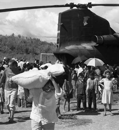
U.S. aid workers rush food, shelter, water and medicai aid to Hondurans made homeiess by Hurricane Mitch in 1998.
The Honduran neo-liberal government of Rafael Leonardo Callejas ratified the Vienna Convention in 1993, and took part in the United Nations Framework Convention on Climate Change signed in Rio de Janeiro in May 1992. The government of Carlos Roberto Flores Facussé signed the Kyoto Protocol to the UN Framework Convention on Climate Change on February 25, 1999, it was ratified on July 19, 2000, and took effect on February 16, 2005.
Bibliography
- Atmospheric Sciences
- Aerosols
- Anticyclones
- Atmospheric Absorption of Solar Radiation
- Atmospheric Boundary Layer
- Atmospheric Composition
- Atmospheric Emission of Infrared Radiation
- Atmospheric General Circulation Models
- Clouds, Cirrus
- Clouds, Cumulus
- Clouds, Stratus
- Condensation
- Convection
- Coriolis Force
- Cyclones
- Doldrums
- Evaporation and Transpiration
- Evolution of the Atmosphere
- Hadley Circulation
- Heat, Latent
- Heat, Sensible
- Hurricanes and Typhoons
- Hydrological Cycle
- Intertropical Convergence Zone
- Jet Streams
- Mesosphere
- Monsoons
- Precipitation
- Radiation, Absorption
- Radiation, Infrared
- Radiation, Long Wave
- Radiation, Microwave
- Radiation, Short Wave
- Radiation, Ultraviolet
- Rain
- Stratosphere
- Thermosphere
- Thunderstorms
- Trade Winds
- Troposphere
- Walker Circulation
- Waves, Gravity
- Waves, Internal
- Waves, Kelvin
- Waves, Planetary
- Waves, Rossby
- Weather
- Winds, Easterlies
- Winds, Westerlies
- Climate
- Abrupt Climate Changes
- Aerosols
- Albedo
- Anthropogenic Forcing
- Carbon Cycle
- Chaos Theory
- Climate Cycles
- Climate Forcing
- Climate Thresholds
- Climate Zones
- Climatic Data, Atmospheric Observations
- Climatic Data, Cave Records
- Climatic Data, Historical Records
- Climatic Data, Ice Observations
- Climatic Data, Instrumental Records
- Climatic Data, Lake Records
- Climatic Data, Nature of the Data
- Climatic Data, Oceanic Observations
- Climatic Data, Proxy Records
- Climatic Data, Sea Floor Records
- Climatic Data, Sediment Records
- Climatic Data, Tree Ring Records
- Detection of Climate Changes
- Earthshine
- El Niño and La Niña
- Gaia Hypothesis
- Global Warming
- Greenhouse Effect
- Greenhouse Gases
- History of Climatology
- History of Meteorology
- Hydrological Cycle
- Internal Climate Variability
- Methane Cycle
- Milankovitch Cycles
- Monsoons
- North Atlantic Oscillation
- Oxygen Cycle
- Seasonal Cycle
- Southern Oscillation
- Sunlight
- Thermodynamics
- Volcanism
- World Systems Theory
- Climate and Society
- An Inconvenient Truth
- Adaptation
- Alternative Energy, Ethanol
- Alternative Energy, Solar
- Alternative Energy, Wind
- Automobiles
- Bush (George W.) Administration
- Capitalism
- Clean Air Act, U.S.
- Clinton Administration
- Coal
- Conservation
- Culture
- Ecological Footprint
- Education
- Environmental Protection Agency (EPA)
- Framework Convention on Climate Change
- Geography
- Globalization
- Greenhouse Effect
- Greenhouse Gases
- Gross National Product
- Health
- Industrialization
- Maximum Sustainable Yield
- Measurement and Assessment
- Media, Books and Journals
- Media, Internet
- Media, TV
- Movements, Environmental
- Needs and Wants
- Nuclear Power
- Oil, Consumption of
- Policy, U.S.
- Population
- Preparedness
- Public Awareness
- Regulation
- Religion
- Resources
- Risk
- Social Ecology
- Sustainability
- Technology
- Tourism
- Climate Change, Effects
- Adaptation
- Agriculture
- Animals
- Arctic Ocean
- Attribution of Global Warming
- Aviation
- Desertification
- Deserts
- Diseases
- Drought
- Economics, Cost of Affecting Climate Change
- Economics, Impact From Climate Change
- Ecosystems
- Floods
- Food Production
- Glaciers, Retreating
- Hurricanes and Typhoons
- Impacts of Global Warming
- Oceanic Changes
- Plants
- Polar Bears
- Rainfall Patterns
- Sea Level, Rising
- Species Extinction
- Thermohaline Circulation
- Transportation
- Tsunamis
- Climate Feedbacks
- Climate Models
- Atmospheric Component of Models
- Climate Model
- Computer Models
- Energy Balance Models
- Historical Development of Climate Models
- Ice Component of Models
- Land Component of Models
- Modeling of Ice Ages
- Modeling of Ocean Circulation
- Modeling of Paleoclimates
- Ocean Component of Models
- Simulation and Predictability of Seasonal and Interannual Variations
- Validation of Climate Models
- Countries: Africa
- Algeria
- Angola
- Benin
- Botswana
- Brunei Darussalam
- Burkina Faso
- Burundi
- Côte d'Ivoire
- Cameroon
- Cape Verde
- Central African Republic
- Chad
- Comoros
- Congo
- Congo, Democratic Republic of
- Djibouti
- Egypt
- Equatorial Guinea
- Eritrea
- Ethiopia
- Gabon
- Gambia
- Ghana
- Guinea
- Guinea-Bissau
- Kenya
- Lesotho
- Liberia
- Madagascar
- Malawi
- Mali
- Mauritania
- Mauritius
- Morocco
- Mozambique
- Namibia
- Niger
- Nigeria
- Rwanda
- São Tomé and Principe
- Senegal
- Sierra Leone
- Somalia
- South Africa
- Sudan
- Swaziland
- Tanzania
- Togo
- Tunisia
- Uganda
- Zambia
- Zimbabwe
- Countries: Americas
- Antigua and Barbuda
- Argentina
- Bahamas
- Barbados
- Belize
- Bolivia
- Brazil
- Canada
- Chile
- Colombia
- Costa Rica
- Cuba
- Dominica
- Dominican Republic
- Ecuador
- El Salvador
- Grenada
- Guatemala
- Guyana
- Haiti
- Honduras
- Jamaica
- Mexico
- Nicaragua
- Panama
- Paraguay
- Peru
- Saint Kitts and Nevis
- Saint Lucia
- Saint Vincent and the Grenadines
- Suriname
- Trinidad and Tobago
- United States of America
- Uruguay
- Venezuela
- Countries: Asia
- Afghanistan
- Azerbaijan
- Bahrain
- Bangladesh
- Bhutan
- Cambodia
- China
- East Timor
- Georgia (Nation)
- India
- Indonesia
- Iran
- Iraq
- Israel
- Japan
- Jordan
- Kazakhstan
- Korea, North
- Korea, South
- Kuwait
- Kyrgyzstan
- Laos
- Lebanon
- Malaysia
- Maldives
- Mongolia
- Myanmar
- Nepal
- Oman
- Pakistan
- Philippines
- Qatar
- Russia
- Saudi Arabia
- Seychelles
- Singapore
- Sri Lanka
- Syria
- Tajikistan
- Thailand
- Turkey
- Turkmenistan
- Ukraine
- United Arab Emirates
- Uzbekistan
- Vietnam
- Yemen
- Countries: Europe
- Albania
- Andorra
- Armenia
- Austria
- Belarus
- Belgium
- Bosnia and Herzegovina
- Bulgaria
- Croatia
- Cyprus
- Czech Republic
- Denmark
- Estonia
- Finland
- France
- Germany
- Greece
- Hungary
- Iceland
- Ireland
- Italy
- Latvia
- Liechtenstein
- Lithuania
- Luxembourg
- Macedonia (FYROM)
- Malta
- Moldova
- Monaco
- Netherlands
- Norway
- Poland
- Portugal
- Romania
- San Marino
- Serbia and Montenegro
- Slovakia
- Slovenia
- Spain
- Sweden
- Switzerland
- United Kingdom
- Countries: Pacific
- Glaciology
- Government and International Agencies
- Air Force, U.S.
- Department of Defense, U.S.
- Department of Energy, U.S.
- Department of State, U.S.
- Geophysical Fluid Dynamics Laboratory
- Global Atmospheric Research Program (GARP)
- Goddard Institute for Space Studies
- National Aeronautics and Space Administration (NASA)
- National Oceanic and Atmospheric Administration (NOAA)
- National Science Foundation
- Navy, U.S.
- Office of Naval Research
- United Nations
- World Health Organization
- World Meteorological Organization
- Institutions Studying Climate Change
- Alaska Climate Research Center
- Alliance to Save Energy
- American Council for an Energy-Efficient Economy
- American Electric Power
- American Gas Association
- American Geophysical Union
- American Meteorological Society
- Antarctic Meteorology Research Center
- Applied Energy Services, Inc.
- Atmosphere, Climate and Environment Information Programme (UK)
- Atmospheric Research and Information Centre
- BP
- Canadian Association for Renewable Energies
- Cantor Fitzgerald EBS
- Center for Clean Air Policy
- Center for Energy Efficiency
- Center for International Climate and Environmental Research
- Center for International Environmental Law
- Center for Ocean-Atmospheric Prediction Studies
- Center for Science and Environment (India)
- Climate Action Network
- Climate Change Knowledge Network
- Climate Impacts LINK Project
- Climatic Research Unit
- Colorado Climate Center
- Cooperative Institute for Arctic Research
- Cornell University
- David Suzuki Foundation
- Department of Energy, U.S.
- Desert Research Institute
- Edison Electric Institute
- Environmental and Societal Impacts Group
- Environmental Defense
- Environmental Development Action in the Third World
- Environmental Financial Products, LLC
- Environmental Protection Agency (EPA)
- European Commission
- FEEM (Italy)
- Florida State University
- Foundation for International Environmental Law and Development
- Friends of the Earth
- Geophysical Fluid Dynamics Laboratory
- Global Atmospheric Research Program (GARP)
- Global Environment Facility (GEF)
- Global Industrial and Social Progress Research Institute (GISPRI)
- Greenpeace International
- Harvard University
- Heinz Center
- Idaho State Climate Services
- Indiana University
- Institute of Energy Economics (Argentina)
- Intergovernmental Panel on Climate Change (IPCC)
- International Council of Scientific Unions (ICSU)
- International Energy Agency (IEA)
- International Institute for Sustainable Development (IISD)
- International Research Institute for Climate Prediction
- International Solar Energy Society (ISES)
- International Union of Geodesy and Geophysics (IUGG)
- Joint Institute for the Study of the Atmosphere and Ocean (JISAO)
- Kyoto Mechanisms
- LDEO Climate Modeling Group
- Marshall Institute
- Midwestern Regional Climate Center
- National Academy of Sciences, U.S.
- National Association of Energy Service Companies (NAESCO)
- National Center for Atmospheric Research (NCAR)
- Natsource
- Natural Resources Defense Council (NRDC)
- New Mexico Climate Center
- OECD Annex 1 Expert Group on the UNFCCC
- OECD Climate Change Documents
- Ohio State University
- Oregon Climate Service
- Oregon State University
- Organisation for Economic Co-operation and Development (OECD)
- Penn State University
- Pew Center on Global Climate Change
- Renewable Energy Policy Project (REPP)
- Resources for the Future (RFF)
- Royal Dutch/Shell Group
- Royal Meteorological Society
- Scripps Institute of Oceanography
- Solar Energy Industries Association (SEIA)
- Stockholm Environment Institute (SEI)
- Tata Energy Research Institute (TERI)
- Trexler and Associates, Inc.
- UN Conference on Trade and Development/Earth Council Institute: Carbon Market Program
- United Nations Development Programme (UNDP)
- United Nations Environment Programme (UNEP)
- University Corporation for Atmospheric Research
- University Corporation for Atmospheric Research Joint Office for Science Support
- University of Arizona
- University of Birmingham, Meteorology and Climatology Department
- University of California
- University of Colorado
- University of Delaware, Center for Climatic Research
- University of Florida
- University of Hawaii, School of Ocean and Earth Science and Technology
- University of Illinois, Department of Atmospheric Sciences
- University of Kentucky, Agricultural Weather Center
- University of Leeds, Institute for Atmospheric Science
- University of Maine, Institute for Quaternary Studies
- University of Maryland, Department of Meteorology
- University of Miami
- University of Michigan
- University of New Hampshire
- University of Oklahoma, Weather Radar
- University of Reading, Department of Meteorology
- University of Utah, Department of Meteorology
- University of Washington, Atmospheric Science Department
- Utah Climate Center
- Weather World 2010 Project
- Western Regional Climate Center
- Woods Hole Oceanographie Institute
- World Bank
- World Business Council for Sustainable Development
- World Meteorological Organization
- World Resources Institute
- World Wildlife Fund
- Worldwatch Institute
- Oceanography
- Agulhas Current
- Antarctic Circumpolar Current
- Arctic Ocean
- Atlantic Ocean
- Benguela Current
- Current
- Ekman Layer
- Equatorial Undercurrent
- Gulf Stream
- Indian Ocean
- Kuroshio Current
- Meridional Overturning Circulation
- Mixed Layer
- Modeling of Ocean Circulation
- Pacific Ocean
- Peruvian Current
- Salinity
- Seawater, Composition of
- Somali Current
- Southern Ocean
- Thermocline
- Thermohaline Circulation
- Upwelling, Coastal
- Upwelling, Equatorial
- Western Boundary Currents
- Wind-Driven Circulation
- Paleoclimates
- Cenozoic Era
- Cretaceous Era
- Earth's Climate History
- Greenland Cores
- Holocene Era
- Jurassic Era
- Mesozoic Era
- Milankovitch Cycles
- Orbital Parameters, Eccentricity
- Orbital Parameters, Obliquity
- Orbital Parameters, Precession
- Paleozoic Era
- Pleistocene Era
- Pliocene Era
- Precambrian Era
- Quaternary Era
- Tertiary Climate
- Triassic Period
- Vostok Core
- Younger Dryas
- People
- Arakawa, Akio
- Arrhenius, Svante August
- Bolin, Bert
- Broecker, Wallace
- Bryan, Kirk
- Bryson, Reid
- Budyko, Mikhail
- Chamberlin, Thomas C.
- Charney, Jule Gregory
- Croll, James
- Fourier, Joseph
- Gore, Albert, Jr.
- Hadley, George
- Hansen, James
- Keeling, Charles David
- Lindzen, Richard
- Lorenz, Edward
- Manabe, Syukuro
- Milankovitch, Milutin
- Munk, Walter
- Phillips, Norman
- Revelle, Roger
- Richardson, Lewis Fry
- Rossby, Carl-Gustav
- Schneider, Stephen H.
- Singer, S. Fred
- Smagorinsky, Joseph
- Stommel, Henry
- Sverdrup, Harald Ulrik
- Tyndall, John
- Von Neumann, John
- Walker, Gilbert
- Washington, Warren
- Programs and Conventions
- Loading...
Get a 30 day FREE TRIAL
-
 Watch videos from a variety of sources bringing classroom topics to life
 -
Read modern, diverse business cases
-
Explore hundreds of books and reference titles

Read next

More like this
Sage Recommends
We found other relevant content for you on other Sage platforms.
Have you created a personal profile? Login or create a profile so that you can save clips, playlists and searches