Entry
Entries A-Z
Subject index
SEA-LEVEL CHANGE
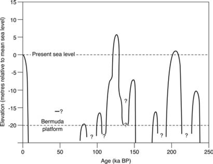
A change in absolute or relative sea level. It is almost impossible to describe former patterns of sea-level change for any area of the world since quantification requires measurement from a common reference level. Owing to the enormous complexity of eustasy, isostasy and tectonics, geological and geomorphological investigations for particular coastal areas only permit reconstructions of former patterns of relative sea-level change (see Figure). The position of relative sea level during the last interglacial varies between regions: in southwest England, it is between 2–5 m above present sea level; in parts of the Netherlands, it is –15 m; and in parts of Greece, it is as high as +200 m. By contrast, during the last glacial maximum (LGM), it is estimated for many areas to have been about –120 m in the open ocean. This value may incorporate several tens of metres of hydroisostaticunloading due to a reduced mass of ocean water caused by diminished volume.
Present estimates of sea-level rise as absolute values are therefore misleading if the impression is given that such estimates apply everywhere. A global sea level or a global sea-level change are not valid concepts. Thus, in Scandinavia, despite human-induced glacio-eustatic rise in sea level, relative sea level is falling in many areas owing to continued glacio-isostatic rebound caused by the melting of the past Fennoscandian ice sheet. In contrast, the amount of recent relative sea-level rise in the world’s major deltas is exceptionally high owing to deltaic subsidence, which is a natural phenomenon exacerbated by human impact (e.g. extraction of oil, gas and water). The Global Sea-Level Observing System monitors long-term variations in sea level using a network of sea-level gauges, the positions of which are fixed by a satellite-based global positioning system (GPS). The latter is providing extremely accurate information on present rates of sea-level rise across the surface of the world’s oceans.
Sea-level changeSea-level change for the past 250,000 years based on high-precision uranium-thorium dating of submerged corals in Bermuda (Harmon et al., 1983; Lowe and Walker, 1997)
[See alsogeoidal eustasy, glacio-isostasy, hydro-isostasy]
...
- Loading...
Get a 30 day FREE TRIAL
-
 Watch videos from a variety of sources bringing classroom topics to life
 -
Read modern, diverse business cases
-
Explore hundreds of books and reference titles

Read next

More like this
Sage Recommends
We found other relevant content for you on other Sage platforms.
Have you created a personal profile? Login or create a profile so that you can save clips, playlists and searches